

Mynydd y Dref [Conwy Mountain]
Good walks are even better shared.
SH7577 : Rhyolite dome
Jonathan Wilkins Photo source
Overview
Mynydd y Dref, or Conwy Mountain, is a 244 m rocky hill immediately west of Conwy on the coastal edge of the Carneddau. The summit ridge carries the Iron Age hillfort of Castell Caer Seion and overlooks the estuary, Great Orme and coast. Walks from Conwy town and Sychnant Pass have different starts and returns. Public footpaths around Capelulo reopened after inspection following the July 2026 wildfire; keep to public paths and heed local fire-damage notices.
Mynydd y Dref [Conwy Mountain]
Overview
Mynydd y Dref is the 244 m rocky hill immediately west of Conwy, on the coastal edge of the Carneddau. Its Welsh name means “Mountain of the Town”. Paths from Conwy and Sychnant Pass reach an open summit ridge with extensive coastal views and the remains of Castell Caer Seion. The ground is uneven, with steep sections and many path junctions.
Summit
DoBIH identifies the high point at SH 75981 77806 as a natural rock 2 m northwest of a large flat-topped rock; the larger rock is only just lower. The hillfort spreads along the ridge, so reaching its ruins alone does not identify the precise high point.
Routes and returns
Conwy town circuit
From Castle Square, follow the quay and harbour to the school, cross the railway footbridge and pass Beechwood Court. Climb onto the hill and continue to the summit. Descend west, then turn east onto the broad track below the southern slope before the lower path junction. Rejoin the outward approach and return to Castle Square. Countryfile publishes 8 km, 279 m ascent and about 3 hours for this moderate circuit.
Sychnant Pass three-hill circuit
Start at the Sychnant Pass lay-by, SH749769. Climb Alltwen and continue north to Penmaen-bach. Head south to meet the North Wales Path and follow it east to Conwy Mountain. From the summit retrace west, cross the stream near SH750774 and follow the Pen Pyra access road back to the lay-by. Walking Britain publishes 4.9 km, 273 m ascent and about 2 hours 20 minutes. It grades the circuit easy/moderate; the short Penmaen-bach scramble is optional. Assess the return ford before committing to it.
Access after the July 2026 wildfire
Conwy County Borough Council announced on 5 August 2026 that public footpaths around Capelulo had been inspected and reopened. It advises staying on public footpaths because extensive fire damage remains, including sections of the informal Dribblers Ridge route. The council's temporary-closure list checked on 17 October 2026 did not list a Conwy Mountain or Capelulo wildfire closure. Follow current signs and any local restrictions; the reopening does not certify every informal track as safe.
Terrain, weather and care
The town route combines harbour paths, roads, a railway footbridge, a steep wooded approach and rocky heathland. The Sychnant circuit adds an optional scramble, faint path sections and a stream crossing. Wet rock and mud require care; strong wind, low cloud or ice can change the character of this low hill. Carry a map, suitable footwear, weatherproof layers and water. Turn back rather than cross a swollen stream. The old northern quarries have vertical cliff faces and should not be explored as shortcuts. Keep dogs on a lead around grazing animals and on the North Wales Path.
Geology and history
The ridge is rhyolite, a volcanic rock. The council leaflet describes volcanic activity roughly 450 million years ago, followed by tectonic tilting and later glacial shaping of the Conwy valley and Sychnant Pass. Quarrying on the northern slopes supplied silica-rich china-stone and later road stone.
Castell Caer Seion, recorded by Cadw as Castell Caer Lleion, is a scheduled pre-Roman Iron Age hillfort. A larger enclosure and a smaller fortified western area preserve evidence of several construction phases. Avoid damaging the walls or moving stones. The mountain is also an urban common with grazing rights.
Views and neighbouring hills
In clear weather the outlook includes Conwy and its estuary, the Great Orme, Conwy Bay and the Carneddau. Alltwen, 255 m, and Penmaen-bach, 245 m, are the nearby separate summits included in the Sychnant circuit. Heathland colour varies with season and post-fire recovery; older photographs do not show current ground conditions.
Getting there and facilities
Conwy has rail and bus connections for the town route. TfW identifies Conwy among the stations converted from request stops to permanent stops; check current journeys and calling patterns. Town parking options include the station, Vicarage Gardens and Morfa Bach. The alternative circuit starts at the Sychnant Pass lay-by; park considerately and keep gates and access roads clear. Conwy offers cafés and pubs, and public toilets are recorded at Morfa Bach. Use town facilities before climbing and carry food and water.
Research references
Checked 17 October 2026. DoBIH 14690 retains its source-row revision of 25 January 2024. Route descriptions are from Countryfile, published 17 July 2023, and Walking Britain, publication date not displayed. Current access wording follows the council's 5 August 2026 reopening notice and closure list. Archaeology follows Cadw CN012; geology and common-land history follow the council leaflet. Transport follows TfW's 6 March 2026 release. Undated records are not assigned a publication date.
Explore routes near Mynydd y Dref [Conwy Mountain]
Walks starting near this hill. Open a route to check its map, distance and full itinerary.
Llyn Crafnant: Lakeside Circuit from the NRW Car Park
View route
Snowdon Pyg Track returning by Miner's Track
View route
Dyserth to Prestatyn: old railway walkway return
View route
Beddgelert Forest: Derwen Circuit and Llyn Llywelyn
View route
Route planning notes
These notes describe possible approaches. Check a route's map and access information when planning your walk.
Conwy town, summit and southern-track circuit
Start at Castle Square and follow the quay and harbour to the school. Cross the railway footbridge, pass Beechwood Court and climb onto Conwy Mountain to the summit hillfort. Descend west, then turn east onto the broad track below the southern slope before the lower path junction. Rejoin the outward approach and return to Castle Square. Countryfile gives 8 km, 279 m ascent and about 3 hours for this full circuit. Follow public footpaths and current fire-damage notices.
Sychnant Pass, Alltwen, Penmaen-bach and Conwy Mountain circuit
Start and finish at the Sychnant Pass lay-by, SH749769. Climb Alltwen, continue north to Penmaen-bach, then head south to join the North Wales Path east to Conwy Mountain. Retrace west from its summit, ford the stream near SH750774 and follow the Pen Pyra access road back to the lay-by. Walking Britain gives 4.9 km, 273 m ascent and about 2 hours 20 minutes for this complete circuit. The Penmaen-bach scramble is optional; do not force the ford in high water. Keep to public footpaths after the wildfire.
Make a day of it, together
Find someone to share the walk with, or organise a day out along a route you like.
Photo Gallery
View all Photo could not load
SH7577 : Rhyolite dome
Jonathan Wilkins
 Photo could not load
SH7677 : Mynydd y Dref / Conwy Mountain (3)
Ceri Thomas
 Photo could not load
SH7577 : Mixed heather and gorse, Conwy mountain
N Chadwick
 Photo could not load
SH7677 : North Wales Path near the summit
N Chadwick
 Photo could not load
SH7677 : Caer Seion/Caer Leion
Eirian Evans
 Photo could not load
SH7577 : Part of the North Wales Path on Conwy Mountain
Jeremy Bolwell
 Photo could not load
SH7677 : The top of Conwy Mountain
Bill Boaden
 Photo could not load
SH7677 : The north side of Conwy Mountain
Bill Boaden
 Photo could not load
SH7577 : The top of Conwy Mountain
Bill Boaden

SH7677 : The Summit of Conwy Mountain
N Chadwick
Hill facts and local notes
Classifications
Elevation
244m
801 ft
Prominence
57m
Coordinates
53.2827, -3.8617
SH759778
OS Map
115
Explorer: OL17E
At the Summit
The natural high point is a rock 2 m northwest of a large flat-topped rock at SH 75981 77806. DoBIH records the larger flat-topped rock as only just lower. The remains of Castell Caer Seion spread across the summit ridge; the precise high point is the natural rock rather than a trig pillar.
Terrain & Geology
The summit ridge is rhyolite, a volcanic rock, rather than slate. The council leaflet describes volcanic ash and lava features formed roughly 450 million years ago, later tilted by tectonic movements. Glaciation shaped the Conwy valley and Sychnant Pass. Old workings on the northern side extracted silica-rich china-stone and later road stone; their vertical quarry faces should be avoided.
Views & Scenery
In clear weather the summit overlooks Conwy and its estuary, Conwy Bay, the Great Orme and the Carneddau. Views and visibility vary with the weather.
History & Heritage
Name Origin
The name 'Mynydd y Dref' translates to 'Mountain of the Town' in Welsh, reflecting its prominence over Conwy.
Historical Significance
Castell Caer Seion, recorded by Cadw as Castell Caer Lleion (scheduled monument CN012), occupies the summit ridge. This pre-Roman Iron Age hillfort has a large enclosure and a smaller fortified western area, with evidence of several construction phases. Do not damage the surviving walls or move stones. Conwy Mountain is also an urban common with grazing rights, historically associated with Aberconwy Abbey and Conwy town’s Royal Charter.
Getting There & Facilities
Parking
For the town circuit, use Conwy parking such as the railway station, Vicarage Gardens or Morfa Bach, then walk to Castle Square. Check current charges and restrictions. The three-hill circuit starts at the Sychnant Pass lay-by, SH749769; keep gates and access roads clear.
Public Transport
Conwy railway station serves the town approach, with bus links from Llandudno, Colwyn Bay and other coastal towns. TfW identifies Conwy among former request stops converted to permanent stops. Check current train calling patterns and bus times before travelling. Public transport to Conwy does not place you at the separate Sychnant Pass trailhead.
Nearby Facilities
Conwy town has cafés and pubs. Public toilets, including accessible facilities, are recorded at Morfa Bach car park on Llanrwst Road; check opening arrangements locally. Use town facilities before climbing and carry food and water.
Safety Information
Known Hazards
- After the July 2026 wildfire, the council reopened inspected public footpaths around Capelulo on 5 August. Extensive fire damage remains, including on informal Dribblers Ridge. Stay on public footpaths, check current council advice and obey on-site closures.
- The northern quarries have vertical cliff faces. Stay away from quarry edges and do not use them as shortcuts.
- The Sychnant Pass circuit includes a short optional scramble on Penmaen-bach, faint path sections and an unbridged stream crossing near SH750774. Turn back if the ford is unsafe.
- Rock, mud and steep paths can be slippery. Wind and low cloud affect the exposed ridge, and numerous path junctions require a map. Keep dogs on a lead around livestock and on the North Wales Path.
Seasonal Hazards
Heavy rain can make the Sychnant circuit’s return ford unsafe and leave paths muddy; ice makes rocky sections slippery. Hot, dry and windy conditions increase wildfire risk. Do not light fires or use disposable barbecues on the hillside.
General Safety Tips
- Check weather conditions before setting out
- Carry appropriate clothing and equipment
- Let someone know your planned route
- Take a map, compass, and GPS device
- Carry emergency supplies: food, water, first aid kit, torch
Hills
Some common questions about the hills answered
Are there group walks up Mynydd y Dref [Conwy Mountain]?
Many walkers use Walkmates to join or organise walks with others. You can check for group walks around Mynydd y Dref [Conwy Mountain] through the maps
Are there other walkers around Mynydd y Dref [Conwy Mountain]?
Activity varies by location and time, but Walkmates lets you see whether others have shared walks or shown interest in this area. Find other people through the walking friends search walking friends for Mynydd y Dref [Conwy Mountain] search or of course create your own walk for Mynydd y Dref [Conwy Mountain]
Can I organise a walk to Mynydd y Dref [Conwy Mountain]?
Yes. If there aren’t any walks listed already, you can create a walk and make it available for others to join.
If you're signed up to Walkmates, you can create a walk to Mynydd y Dref [Conwy Mountain].
How do I find a walk up this hill?
There are often multiple ways to walk this hill, depending on experience and route preference. Walkmates helps you explore walks and routes that others have shared.
Can I suggest a new route up Mynydd y Dref [Conwy Mountain]?
Yes. You can suggest or create routes to share with others. Walkmates focuses on the social side of walking, so routes are used to help people organise walks and explore areas together, rather than as detailed navigation tools or route libraries.
Other uses really appreciate knowledgeable walkers sharing their routes. Share your favourite route to Mynydd y Dref [Conwy Mountain] here
The is an error or something incorrect about this hill. How do I let you know?
We always strive to keep the information on Walkmates as accurate as possible. If you find an error, please let us know through the contact form and we'll aim to correct it as quickly as possible
Community Discussion
Comments
Location
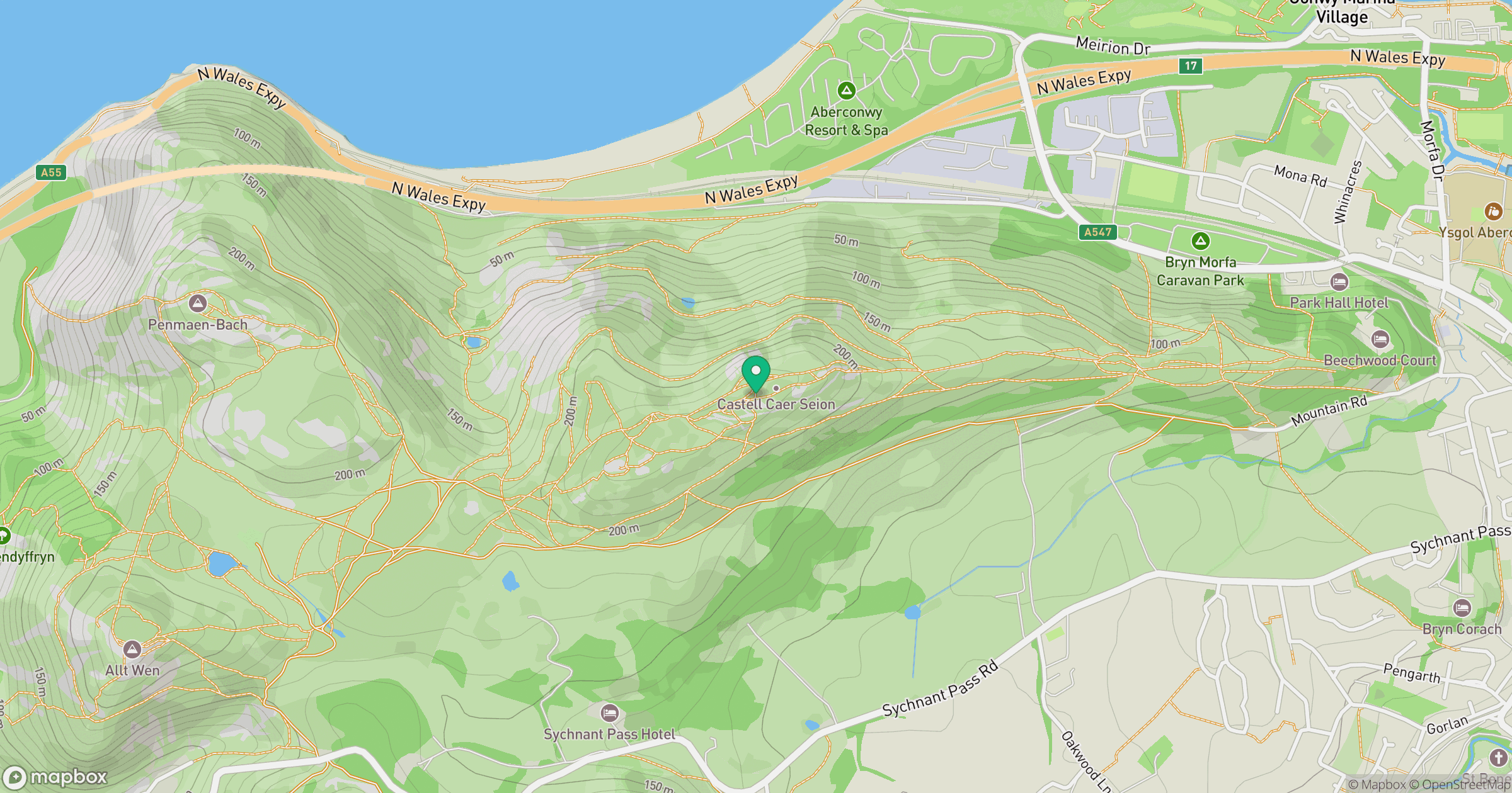
Grid reference: SH759778
View on OpenStreetMapOpens a map in a new tab, centred on the hill.
Nearby Hills
Great Orme [Y Gogarth]
207m
Carnedd Llewelyn
1,062m
Carnedd Dafydd
1,044m
Tryfan
918m
Moel Siabod
872m
No comments yet. Be the first.